Stories from the kampungs of Batavia
Essay by Lara Voerman
Introduction
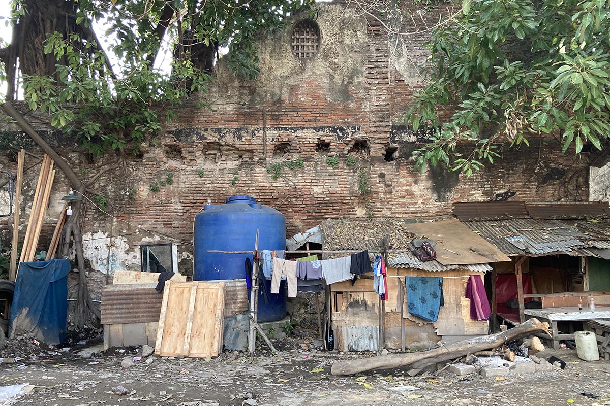
This essay highlights nine kampungs in Jakarta, all of which are located in Kota Tua, the oldest part of Jakarta. The kampungs of Susun Akuarium, Kerapu, Lodan, Tongkol, Walang, Bonpis, Susun Kunir, Balokan, and Muka border the edge of Batavia—the fortified city that served as the Dutch East India Company’s headquarters in Asia from 1619 to 1799. Batavia’s perimeter was once defined by a six-meter-high wall and a wide city moat. Today, only a few sections of the wall remain. For decades kampung residents build on, near or against these remnants and even repurpose the durable Dutch-made red bricks. Though much of the wall is gone, its influence persists in the lives of these residents, as they contend with the challenges posed by evictions and the frequent flooding of the area’s old canals.
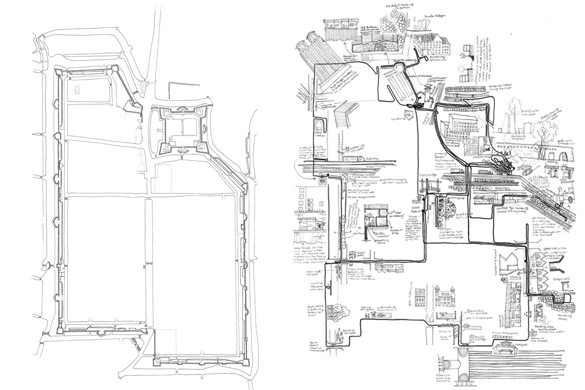
The title of this story and the research it documents, is In/Visible Walls. Where the wall (visible or invisible) meets the kampungs, centuries collide, along with new and old ideas about oppression and freedom, and about what a city should be, look like, and who should live within it. This boundary reveals a friction between the planned and unplanned city, between heritage deemed valuable and communities seen as dispensable, and between resilience and vulnerability. In 2024, a research team from Indonesia and the Netherlands, working with kampung residents, explored the spectrum of stories that emerge when diverse histories intersect.
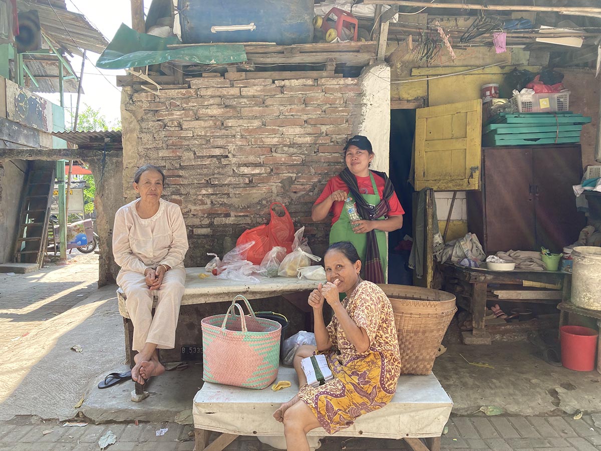
For decades, the nine kampungs have been vibrant communities in Kota Tua, deeply woven into the city’s history. Some of these kampungs have occupied the same land continuously since the 19th century, yet their stories remain largely undocumented. We aimed to change that by exploring their history in multiple ways: first, by critically examining the existing narrative, and second, through community dialogues—conversations with kampung residents that uncover both individual and collective histories. Our site analyses and drawings literally put the kampungs on the map, in a way they have never been before. Additionally, this work sought to raise awareness of how easily “others” can be overlooked in historical documentation, emphasizing the importance of diverse perspectives.
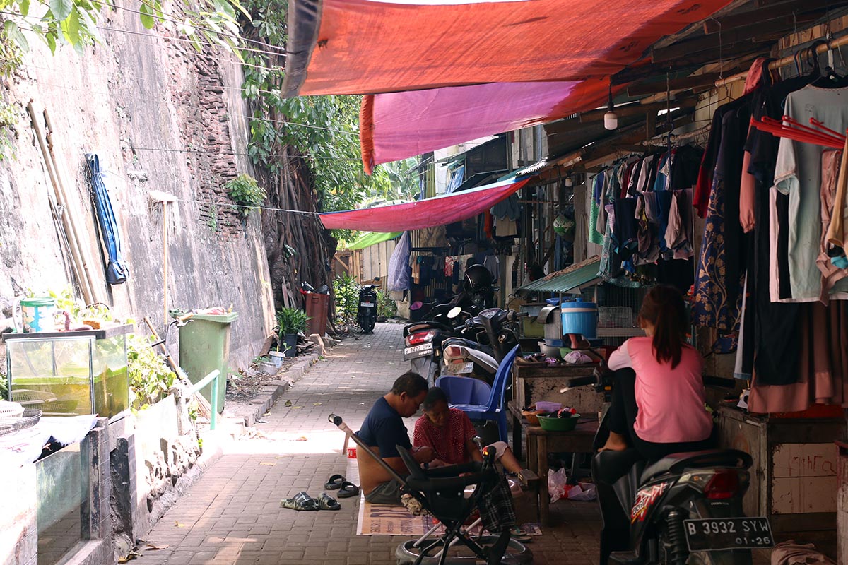
Kampungs are urban residential communities that develop outside official government planning regulations. In Jakarta’s dense metropolis, any available open space, no matter how small, becomes a potential site for building a home—especially for those with limited financial resources. Some kampungs emerge in areas unsuitable or unsafe for living: for example, along or beneath highways and train tracks, or in flood-prone zones. The communities usually lack access to government-built infrastructure, such as roads, sewage systems, street lighting, or running water. Houses here are self-built from a mix of materials, as available and affordable.
Value
As we have seen, history is not merely a list of facts; it is a complex and ever-evolving construct of perspectives and interpretations. The narrative of Batavia has been shaped primarily by sources created and preserved by dominant groups in society. The In/Visible Walls project aims to highlight the often-overlooked kampung perspective on history, paving the way for a more inclusive and equitable approach to heritage. The cultural and historical significance of a place or building extends beyond its physical structure; it encompasses the societal narratives it conveys, the reflections it offers of our contemporary world, and the meanings it holds for its residents. To fully understand heritage—especially colonial heritage—one must embrace a broad perspective and an open mindset. While the remnants of Batavia clearly possess historical value, their contemporary significance is equally important. For the kampungs, the wall—whether visible or invisible, with its positive and negative associations—could and should serve as a repository of stories, a cornerstone of identity, and a symbol of home, rather than an object of liability.
Opening Up the Narrative
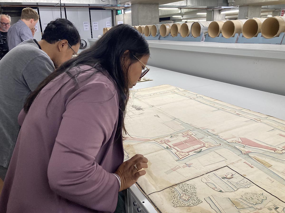
Our research begins with a visit to the National Archives in The Hague, where the records of the Dutch East India Company (VOC) are kept. Here, we see how Batavia grew, step by step, into the administrative hub and warehouse of the VOC in Asia, becoming home to Dutch, Chinese, Javanese, Ambonese, and many other communities. Alex Enzlin, the project leader for International Heritage Cooperation at the archives, has laid out a selection of historical maps for us. The oldest, created around 1620, detail Governor-General Jan Pieterszoon Coen’s plans for a grand new fort that would solidify the VOC’s dominance in the region. This “Castle Batavia” took over a decade to build. The square structure, with its earthen walls and pointed bastions at each corner, reflected high hopes for future wealth, as shown by their names: Diamond, Ruby, Pearl, and Sapphire. The “castle” sat on the eastern bank of the Ciliwung River, right along the coast of the Java Sea. The houses of today’s kampung Kerapu now stand on what was, four centuries ago, the coastline. Back then, its residents would have looked out over the sea, with a sixteen-foot (almost five-meter) high castle wall behind them. Today, that’s hard to picture: through land reclamation and infill, at least a kilometre of densely populated land now stretches between the site of the former fort and the sea.
A new order on the banks of the Ciliwung
In the decades following the construction of the fortress, a rectangular city gradually took shape in the swampy area south of the fort, as shown by other maps in the National Archives. This development happened in two phases: first, half of the city was built on the eastern bank of the Ciliwung River, and later, the other half on the western bank. While it remains uncertain if mathematician Simon Stevin contributed directly to these plans, his influence seems likely. The map of Batavia, drawn around 1650, reflects Stevin’s vision of an ideal city: strictly organized, geometric, and orderly. A five-kilometre wall, with a base of locally mined coral stone and built up out of massive Dutch bricks, enclosed a network of intersecting canals and roads arranged in a grid pattern, resembling woven fabric on a loom. Offshoots of the Ciliwung created the “Stads Buitengrachten” (outer city canals) to the east and west. The Ciliwung itself was straightened and became known as the “Groote Rivier” (Great River), serving as the central axis, wide enough for the largest sailing ships to navigate directly into the city.
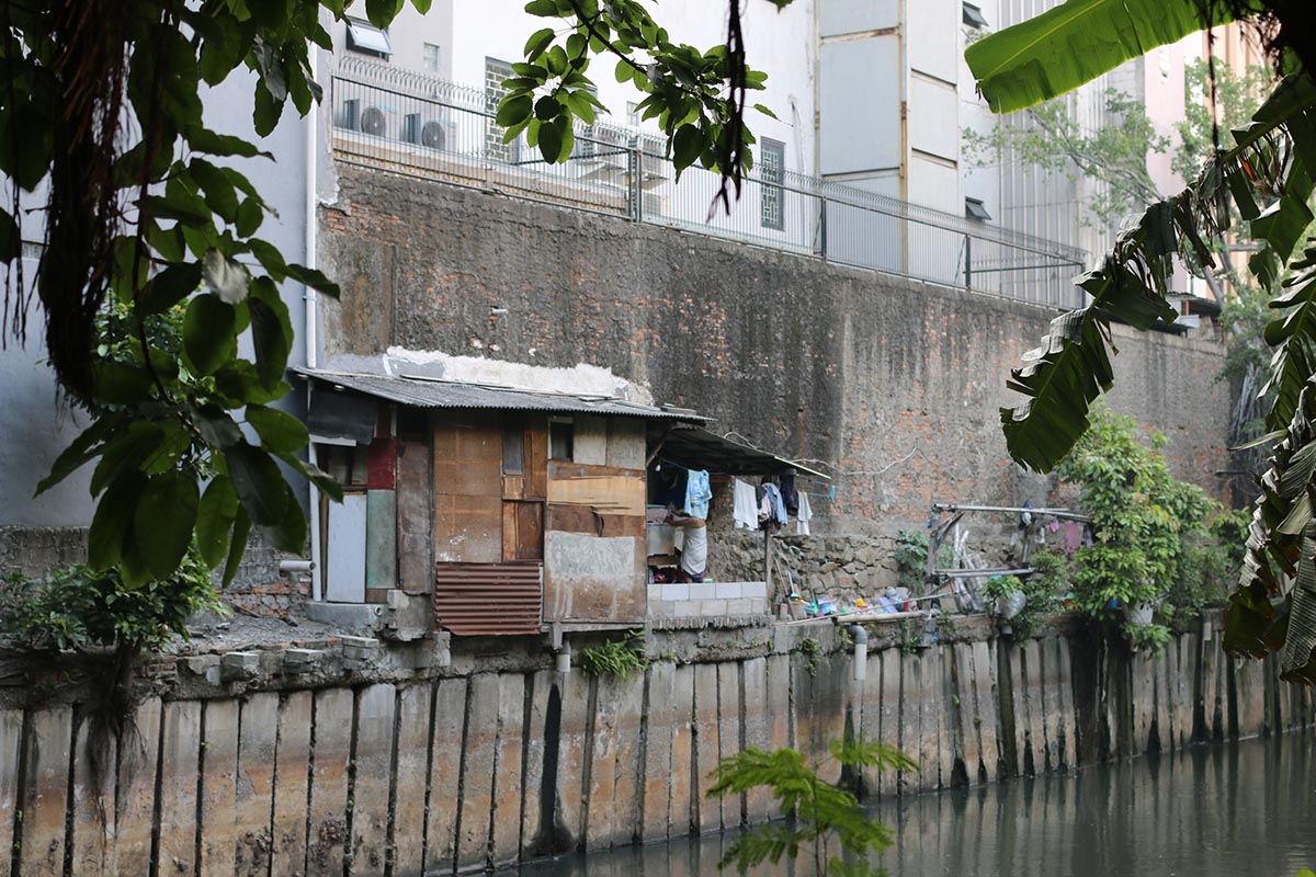
Two weeks after our visit to the National Archives, we stand in Kota Tua along the banks of the Kali Besar, trying to imagine the city as it once was. Today, the Great River flows within towering concrete walls designed to restrain the Ciliwung’s turbulent waters during high tides. Kampung houses turn their backs to the canal, while countless small sewage pipes extend through the concrete, emptying into the caramel-coloured water. Fortunately, we have a tool to bridge past and present: a 17th-century map of Batavia overlaid on a current aerial photo. This projection lets us visualize and compare the two eras as we walk. Although the city wall vanished two centuries ago (save a few remnants, but we’ll get back to that later), the layout of the central canal, the two outer canals, and the grid of streets continues to shape the experience of Kota Tua to this day.
A Divided City
Stevin’s ideal city was envisioned not only as a model for urban and military planning but also as a framework for a certain society. In this ideal, every member of society had a place. However, when this European concept was transposed to a colonial context, its intent shifted: it became a tool for segregation. When one group asserts its dominance and sees itself as superior, exclusion follows as a matter of course. In Batavia, this led to a city divided—a city within the walls and another beyond. In the early years, people of all backgrounds were allowed within the fortress, though in separate quarters—labourers, Chinese, and Javanese, for example, each had their own designated areas.
After around 1660, however, Dutch colonists began excluding the poorest non-Christian Asians (such as the Chinese, Moluccans, Ceylonese, and Ambonese), along with the enslaved (by 1689, about 26,000 enslaved people lived in Batavia, a number equivalent to the population of a medium-sized Dutch city). These groups were increasingly relocated to specific neighbourhoods outside the city walls. In 1667, bamboo houses were banned within the city limits, ostensibly due to fire hazards, but the effect was to intensify the divide between the rich and the poor. Inside the walls, the city became one of sturdy brick, glass windows, and tiled roofs; outside, it expanded with makeshift bamboo and palm structures.
The origins of today’s urban kampungs trace back to these historical “quarters” and neighbourhoods. With their exclusion, a foundation was laid 365 years ago for the divisions that still shape Jakarta today, influencing ideas about who truly belongs in the city and who does not. The old maps we examine in the National Archives serve as symbolic reminders of this. While Batavia boasts a rich history of detailed maps, drawings, paintings, and written records, the story of the kampungs—and especially that of their inhabitants—remains largely hidden. Kampungs outside the walls were often deliberately omitted, either as a denial of their existence or because European mapmakers lacked the conceptual framework to accurately depict them. As a result, the kampungs appeared as vague, schematic dots, devoid of detail—and therefore of acknowledgment.
Demolition
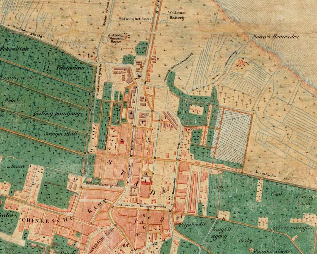
The walled city, designed and constructed by the Dutch in two major campaigns between 1619 and 1650, was dismantled between 1809 and 1820. Not only did the lay out of the Dutch ideal city prove incompatible with colonial society, the water system they designed was ill-suited to the low, muddy coastal plains and the unpredictable Ciliwung River. By the eighteenth century, the city’s canals had become shallow, stagnant open sewers. Malaria drove mortality rates sky-high. For Herman Willem Daendels, then Governor-General in Batavia, the solution was clear: he ordered the demolition of the high city walls and the fortress, allowing the sea breeze to disperse the “contaminated vapours.” The rubble was repurposed as building material for his new government palace, while other sources tell us that the bricks can be found throughout the city in the paving and sidewalks. Around 1820, a cholera epidemic led city authorities to fill in eight long canals. The Dutch began to move southward out of the city, establishing the newer, elevated neighbourhoods of Weltevreden and Rijswijk. Those who remained behind simply couldn’t afford to leave. The old city was effectively abandoned, evoking a clear parallel with the current plan to relocate the capital to Nusantara.
The Rijksmuseum in Amsterdam has a map in its collection that vividly captures the old city’s transformation. This map, drawn in 1866, shows the walls gone and the once-straight city canals beginning to meander in places. Particularly in the eastern half of the city, the extent of demolition is striking. The map reveals how, by the 19th century, the two Batavia’s—the one inside the walls and the one outside—had started to merge spatially. Kampungs gradually filled the vacant lots. While the Dutch mapmaker meticulously illustrated each building in the new southern suburbs, he represented the kampungs simply as green areas dotted with palm trees, shrubs, and scattered symbols. Rows of tiny, repetitive rectangles indicate bamboo and wooden houses, not considered worth depicting individually. The message of the map is clear: even as the two Batavia’s grew closer and became mutually dependent, they remained separate worlds, each with its own spatial logic, as well as written and unwritten rules.
Living Heritage
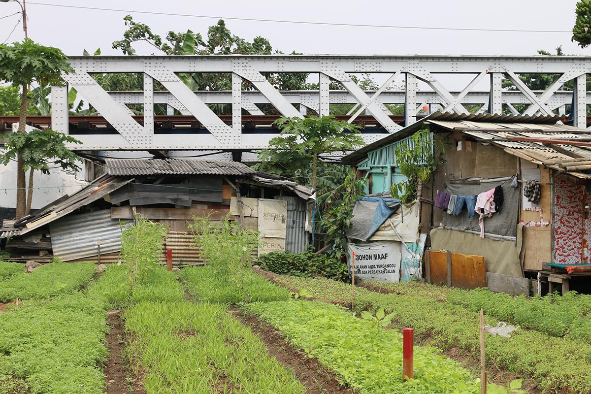
The kampungs became an inseparable part of old Batavia—in this period known as the “Benedenstad” (Lower City), contrasting with the higher district of Weltevreden. The name is still fitting: the area now sits below sea level, leading to frequent floods. By the late 19th century, Kota Tua’s character began to change. For a while sparsely populated, the area transformed into a centre of trade offices, insurance firms, banks, and oil companies, mainly along the Kali Besar and around Taman Fatahillah square. Large warehouse complexes sprang up in less prominent areas, like the abandoned castle grounds, while a new train station, with its sprawling tracks, symbolically opened the formerly walled city of Batavia to the east, attracting more trade activity, especially lumber merchants. Elevated train tracks sliced through the city, skimming the former castle site and isolating the top of Kota Tua from the surrounding areas. Modernization quite literally thundered over history.
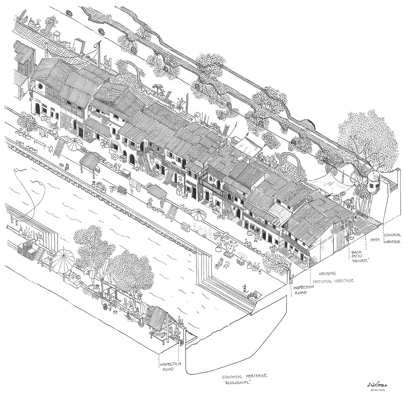
Today, the experience of a historical boundary between Batavia and its surroundings is largely preserved thanks to the kampungs. As Batavia grew into a trade hub, more kampungs sprang up, inhabited by residents working in warehouses and industries on the city’s edges. With no government-funded housing, residents built their own homes, settling behind buildings along main roads, next to railway tracks, and on the land near the outer canals, the castle and abandoned VOC-warehouses—no man’s land freed up by the city wall’s demolition. Along Batavia’s easternmost canal, nine kampungs—Susun Akuarium, Kerapu, Lodan, Tongkol, Walang, Bonpis, Susun Kunir, Balokan, and Muka—grew, especially during the 1960s and 1970s. Through their presence, homes, and daily lives, these kampungs have redefined the long gone 17th-century boundary with a new sense of living heritage.
Kampung Tongkol
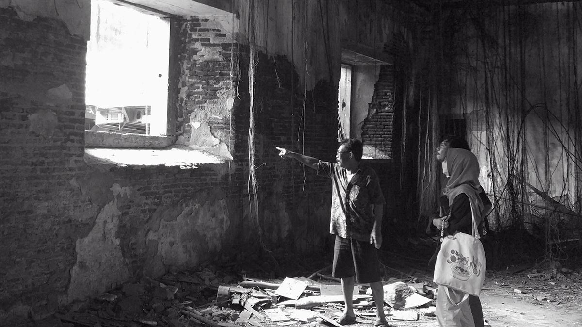
The colonial legacies—both physical structures and ingrained ideas—continue to shape life in the kampungs of Kota Tua, often in ways that are far from positive. We illustrate this with two examples, beginning with Tongkol, a community of about fifty families on the bank of the Kali Ciliwung, once the city’s Outer Canal. Starting at the back of the houses, out of sight, people do their laundry, scooters are parked, and stairs lead to second floors. The most striking feature, however, is a seven-meter-high wall looming over the houses. Nearly four centuries old, the wall is around three meters thick at the base, tapering toward the top. Atop the wall is the “wallwalk,” a protected pathway now fully overgrown with trees, with long aerial roots stretching down its sides. This wall remains for practical reasons: between 1748 and 1759, two elongated grain warehouses, known as the Eastside Warehouses, were built in front of the castle square. Later, these buildings became munitions warehouses and continued as such when they transferred to Indonesian military control after Independence.
The stories from Kampung Tongkol’s residents mostly reflect the warehouses’ military past—and they are far from pleasant. At dusk and into the night, they say, one can hear the cries of an enslaved woman, interrupted by the heavy footsteps of a soldier. When we visit at dusk, residents follow us up to the wall’s gateway, but they don’t go inside. Nor do they live there; instead, the area is used for a community toilet, a truck storage area, and, in the middle, a small soccer field—a rare luxury for children in a city where any free space is quickly occupied.
Along the riverbank, the legacy of the Outer Canal took a darker turn fifteen years ago. In 2010, the city council banned construction within five meters of the riverbank for health and safety reasons. This policy posed an existential threat not only to Kampung Tongkol but to all kampungs that line the Ciliwung, as most homes partially encroached on the newly prohibited five-meter zone. This legislation followed a century-old pattern of evictions and “improvement programs” based on the perception that kampungs are messy, dirty, and unsafe—an idea rooted in 17th-century Batavia. Those residents who chose to stay demonstrated inspiring resilience, cutting five meters off their already modest homes to comply with the regulation. Fifteen years later, these changes remain visible: walls appear abruptly cut off, some streets are paved with kitchen and bathroom tiles, and a ceiling lamp now hangs outside instead of inside. But the new street along the water is now lined with fruit trees, where people meet, work, and pray. Hemmed in between wall and canal, Tongkol carved out its own space in Kota Tua—not thanks to heritage, but in spite of it.
Kampung Susun Kunir
In most other kampungs, the wall is no longer physically present, or it remains hidden, with its foundations lying meters deep underground. Yet, it still holds power, as the following example demonstrates. Kampung Kunir, located a bit further south along the Ciliwung River, encountered similar legislation in 2010, but in Kunir, all the homes were demolished in 2015. For the roughly 35 families who had the patience and resilience to wait, a new vertical kampung was built slightly set back from the river: Susun Kunir. Architects Kamil and Kano immersed themselves in the lives of the future residents: they studied their daily practices, such as how kitchens are used, how homes double as businesses, where laundry is hung (and where women share stories in the meantime), and where children love to play. This understanding led to a compelling building design: a three-story structure with an open ground floor facing the street.
Before construction could begin, however, there were obstacles to overcome. Wall remnants were expected to be buried underground, and the heritage body gave conservation status to the foundation—though notably unexcavated. How to handle this legacy was unclear, except for one thing: it must remain untouched. It felt as if the residents had to fight for their right to exist—despite having lived here for over sixty years—against the foundation of a wall that might lie somewhere beneath them. “It is as if we are still occupied”, one resident sighed. Finally, after considerable persuasion and a revised design, permission was granted. This struggle made the residents of Kunir aware that, for others, it is far from obvious that they too deserve a place in history. For this reason, Kampung Kunir now calls itself “Kota Tua’s kampung,” a motto that proudly affirms its connection to this place.
This research was made possible by the Creative Industries Fund and the Nieuwe Instituut, through their Open Call Hidden (Hi)stories initiative, which seeks out narratives often excluded from official histories.
The team includes architect and researcher Kamil Muhammad, Kampung Kunir Cooperative coordinator Indri Yuliyani, architects Kano Akbar and Dino Bramantyo, anthropologist and filmmaker Aryo Danusiri, architects Isabel Driessen and Andrés López, and architectural historian Lara Voerman. In addition to numerous online meetings, the team spent three weeks together in both the Netherlands and Indonesia, collaboratively exploring the intertwined histories of the wall and the kampungs.
Year:
2024
Location:
Jakarta, Indonesia
Funding:
Stimuleringsfonds voor de Creatieve Industrie / Het Nieuwe Instituut
Type:
Research
Team:
Isabel Driessen and Andrés López
In collaboration with:
Architect and researcher Kamil Muhammad, Kampung Kunir Cooperative coordinator Indri Yuliyani, architects Kano Akbar and Dino Bramantyo, anthropologist and filmmaker Aryo Danusiri and architectural historian Lara Voerman